Category Archives: Geomorphology

What controls the height of mountains?

Read about this at Earth-logs

Maintenance of Earth-pages has stopped. If you wish to continue following reports on significant research developments in Earth science you can register as a follower of my new blog at the Earth-logs site

Evolution of the River Nile

The longest river in the world, the Nile has all sorts of riveting connotations in terms of archaeology, Africa’s colonial history, the romance of early exploration and is currently the focus of disputes about rights to its waters. The last stems from its vast potential for irrigation and for hydropower. It is probably the most complex of all the major rivers of our planet because it stretches across so many climatic zones, topographic systems geological and tectonic provinces. Mohamed Abdelsalam of Oklahoma State University, who was born in the Sudan and began his career at the confluence of the White and Blue Nile in its capital Khartoum, is an ideal person to produce a modern scientific summary of how the Nile has evolved. That is because he has studied some of the key elements of the geology through which the river and its major tributaries travel, but most of all because he is a leading geological and geomorphological interpreter of remotely sensed data. Only space imagery can let us grasp the immense span and complexity of the Nile system. His recent review of its entirety (Abdelsalam, M.G. 2018. The Nile’s journey through space and time: A geological perspective. Earth Science Reviews, v. 177, p. 742-773; doi: 10.1016/j.earscirev.2018.01.010) is a tour de force, many years in the compilation, and it makes fittingly compulsive reading.

Abdelsalam lays out the geomorphology, underlying geology and regional tectonics of the Nile drainage basin, synthesized from publications over the last century, including his own work on the evolution of the Blue Nile in Ethiopia. On the regional scale elements of its complexity can be ascribed to the upwelling of mantle plumes beneath the Ethiopian Highlands and Red Sea, and under the Lake Plateau centred on Kenya, Tanzania, Rwanda and Burundi. These plumes are part of a much larger mantle mass rising from the core-mantle boundary beneath the African continent. Their influence on the lithosphere of north-east Africa began over 30 million years ago, producing vast outpourings of flood basalts followed by regional doming, the formation of large shield volcanoes and rifting to transform a once muted surface to one with a topographic range of up to 5 kilometres in the Nile’s two main source regions in Ethiopia and the Lakes Plateau.

Nile geology F5

The geological underpinnings of the Nile system (Credit: Abdelsalam 2018; Fig. 5)

The basin can be divided into six distinct provinces, from south to north the Lakes, Sudd, Central Sudan, Ethiopia – East Sudan, Cataract and Egyptian Niles. Each of them has had a different history; in fact, the making of the Nile system as we know it has taken at least 6 million years and probably longer. For instance, the Lakes Nile basin, founded mostly on Precambrian crystalline basement, seems original to have drained westward through the Congo system to the Atlantic Ocean. Sometime between 20 and 12 Ma the western branch of the East African Rift System began to form along with slow, broad uplift, hindering westward flow to create the forerunners of the Great Lakes. The flow was reversed around 2.5 Ma ago by the rise of the Rwenzori and Virunga massifs on the western rift flank and eventually forced northwards into the low-lying Sudd, breaching a major divide in Northern Uganda. The vast swamps there have acted as a buffer for sediment supply, other than the finest silts and clays, into the northern stretches of the White Nile. The Blue Nile’s tortuous trajectory evolved as the Ethiopian flood basalt province rose after 30 Ma, rifted to form the Lake Tana Basin and drained to initiate erosion into the rising plateau with the interference of huge shield volcanoes that formed as uplift proceeded.

Other events are recorded along the Nile’ general trajectory by huge, abandoned alluvial fans, relics of now vanished lakes and evidence from satellite radar of palaeo-drainages with reversed flow beneath the surface of the eastern Sahara. The system evolved episodically, in five or more steps, at the whim of broad tectonic processes that affected flow direction and erosive capacity. The Cataract Nile that cuts through hard basement rocks perhaps records the increase in energy added by the Blue Nile which, which in turn may have encouraged the drainage of the huge Sudd swamps that established the White Nile’s course. Even the Mediterranean Sea played a role: the Egyptian Nile may have formed when the sea vanished to expose a deep saline basin during the Messinian Salinity Crisis 5.5 Ma ago. This reduction in the regional base level of erosion possibly directed drainage into the present course of the Nile. The various provinces only became a unified drainage system during the last half million years, and that emerged in its present form as recently as 15 thousand years ago.  But as Abdelsalam points out, there is a great deal to learn about the fabled river system. Hopefully his review will encourage others to take investigations forward and into previously unstudied regions.

Fish influence mountain ranges

When asked if he would like water in his whisky W.C Fields famously remarked that he didn’t drink water because fish procreate in it (his actual words were somewhat racier). Migratory salmon do so in their millions with a great deal of energy, specifically in the gravel beds of high-energy streams. Before spawning, females lash the stream bed with their tails to create a pit or redd in the gravel, in which they lay their eggs to be fertilised  by males. Then she fills-in the redd with more gravel excavated from upstream. Salmon spawning grounds are thus easily recognised as pale patches of freshly overturned gravel on a stream bed that also contain lower amounts of fine sediment and are thereby loosened. As well as discouraging bibulous old men from diluting their liquor, it occurred to Alexander Fremier of Washington State University and other American colleagues that here was a noteworthy example of an active part of the biosphere physically intervening in the rock cycle. Not that it comes even close to what humans have become capable of since the Industrial Revolution, but it might be an object lesson in the fragility of what are otherwise the robust processes of erosion. Moreover, since salmon emerged at some time in the past, their actions might help demonstrate that evolutionary events – speciation, adaptive radiations, mass extinctions etc – play a role in transforming geological processes.

Pacific salmon are semelparous or "big ba...

Pacific Sock-eye salmon that die shortly after spawning (credit: Wikipedia)

Fremier and colleagues (Fremier, A.K. et al. 2017. Sex that moves mountains: The influence of spawning fish on river profiles over geologic timescales. Geomorphology online publication; doi.org/10.1016/j.geomorph.2017.09.033) modeled the consequences of salmon spawning habits for the critical stress needed to set grains in motion, theoretically and in a flume tank. Based on a significant reduction of the critical stress, models for the evolution on various river profiles in the vicinity of salmon spawning grounds suggest that river beds may cut deeper at rates up to 30% faster than they would in the absence of salmon. Were salmon to be reduced or extirpated through dam construction or overfishing then sedimentation in channels would increase. In some areas of extensive farming of salmon in offshore pens, escape and colonization of rivers would eventually change sedimentation and erosion patterns. The findings vary from species to species, but salmon may have had a significant effect on generally rugged landscapes following their appearance in local ecosystems.

The terrestrial-marine-terrestrial migratory habits of salmon, including the return of adults to their birth rivers to spawn, are uncommon if not unique. Their forbears must have evolved to this behaviour at some time in the geological past, separately in the case of North Atlantic and North Pacific species. The authors suggest that adaptive radiation of salmon may have been favoured by orogenic events in western North America around 100 Ma ago that created the system of fast flowing rivers that salmon favour. In turn, salmon may have significantly influenced Western Cordillera landscapes of Alaska, Canada and the conterminous Unites States. A nice example of the inseparability of cause and effect on the scale of the Earth System.

When did the Greenland ice cap last melt?

The record preserved in cores through the thickest part of the Greenland ice cap goes back only to a little more than 120 thousand years ago, unlike in Antarctica where data are available for 800 ka and potentially further back still. One possible reason for this difference is that a great deal more snow falls on Greenland so the ice builds up more quickly than in Antarctica. Because ice flows under pressure this might imply that older ice on Greenland long flowed to the margins and either melted or calved off as icebergs. So, although it is certain that the Antarctic ice cap has not melted away, at least in the last million years or so, we cannot tell if Greenlandic glaciers did so over the same period of time. Knowing whether or not Greenland might have shed its carapace of ice is important, because if ever does in future the meltwater will add about 7 metres to global sea level: a nightmare scenario for coastal cities, low-lying islands and insurance companies.

Margin of the Greenland ice sheet (view from p...

Edge of the Greenland ice sheet with a large glacier flowing into a fjiord at the East Greenland coas  (Photo credit: Wikipedia)

One means of judging when Greenland was last free of ice, or at least substantially so, is based on more than a ice few metres thick being opaque to cosmic ‘rays’. Minerals, such as quartz, in rocks bared at the surface to ultra-high energy, cosmogenic neutrons accumulate short-lived isotopes of beryllium and aluminium – 10Be and 26Al with half-lives of 1.4 and 0.7 Ma. Once rocks are buried beneath ice or sediment, the two isotopes decay away and it is possible to estimate the duration of burial from the proportions of the remaining isotopes. After about 5 Ma the cosmogenic isotopes will have decreased to amounts that cannot be measured. Conversely, if the ice had melted away at any time in the past 5 Ma and then returned it should be possible to estimate the timing and duration of exposure of the surface to cosmic ‘rays’. Two groups of researchers have applied cosmogenic-isotope analysis to Greenland. One group (Schaefer, J.G. et al. 2016. Greenland was nearly ice-free for extended periods during the Pleistocene. Nature, v. 540, p. 252-255) focused on bedrock, currently buried beneath 3 km of ice, that drilling for the ice core finally penetrated. The other systematically analysed the cosmogenic isotope content of mineral grains at different depths in North Atlantic seafloor sediment cores, largely supplied from East Greenland since 7.5 Ma ago (Bierman, P.R. et al. 2016. A persistent and dynamic East Greenland Ice Sheet over the past 7.5 million years Nature, v. 540, p. 256-260). As their titles suggest, the two studies had conflicting results.

The glacigenic sediment grains contained no more than 1 atom of 10Be per gram compared with the 5000 to 6000 in grains deposited and exposed to cosmic rays along the shores of Greenland since the end of the last ice age. These results challenge the possibility of any significant deglaciation and exposure of bedrock in the source of seafloor sediment since the Pliocene.  The bedrock from the base of Greenland’s existing ice cap, however, contains up to 25 times more cosmogenic isotopes. The conclusion in that case is that there must have been a protracted, >280 ka, exposure of the rock surface in what is now the deepest ice cover at 1.1 Ma ago at most. Allowing for the likelihood of some persistent glacial cover in what would have been mountainous areas in an otherwise substantially deglaciated Greenland, the results are consistent with about 90% melting suggested by glaciological modelling.

Clearly, some head scratching is going to be needed to reconcile the two approaches. Ironically, the ocean-floor cores were cut directly offshore of the most likely places where patches of residual ice cap may have remained. Glaciers there would have transported rock debris that had remained masked from cosmic rays until shortly before calved icebergs or the glacial fronts melted and supplied sediment to the North Atlantic floor. If indeed the bulk of Greenland became ice free around a million years ago, under purely natural climatic fluctuations, the 2° C estimate for global warming by 2100 could well result in a 75% glacial melt and about 5-6 m rise in global sea level.

Read more about glaciation here and here.

Scablands: megaflood hypothesis tempered

Channeled Scablands during flood

Channeled Scablands at the time of a glacial lake outburst flood (credit: Wikipedia)

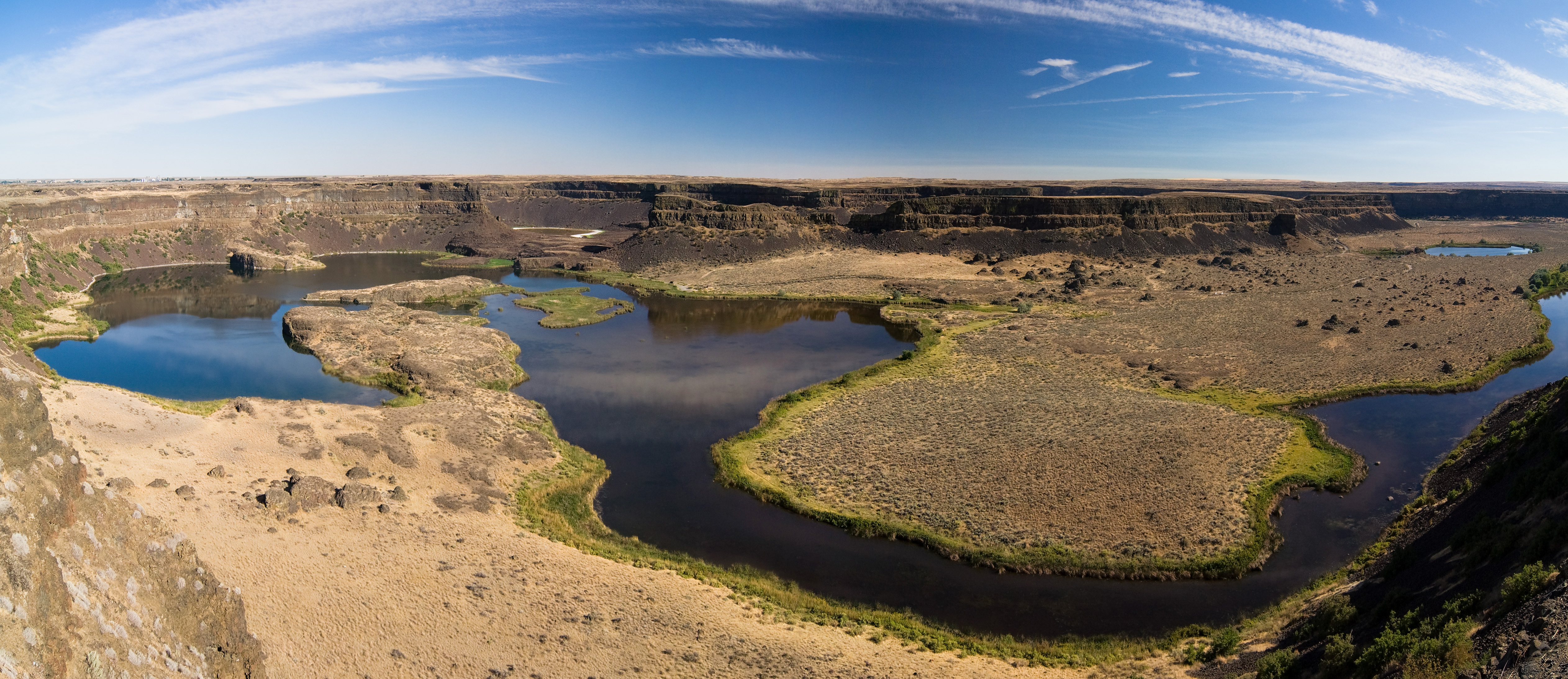
The eastern side of Washington State in the US includes a vast, barren area that has been scoured virtually free of superficial sediment, including soils. Its landscape is among the most odd in North America, consisting of a network of unusually wide canyons or couleés that incise a regional plateau formed by the Columbia River flood basalts. The now largely dry canyon floors contain immense potholes, megaripples and erratic boulders, together with strangely streamlined hillocks made of residual, windblown loess deposits, which collectively resemble features of normal river beds but at a gargantuan scale. The canyon network emerges from the Rocky Mountains near the city of Spokane, then criss-crosses what had previously been a wide basalt plain to merge with the Columbia River in southern Washington. The couleés are up to 100 km long and reach  100 m in depth.

Dry Falls, WA Français : Les Dry Falls dans l'...

Dry Falls in Grand Colee, Washington state, US, showing typical features of the Channelle Scablands. (credit: Wikipedia)

In the 1920s J. Harlen Bretz suggested that the Channelled Scablands had been formed by a massive flood, a view that met disbelief until his colleague Joseph Pardee discovered that a huge lake of glacial meltwater (Lake Missouala) had formed in the intricate valleys of the Montana Rockies when their outflow into Washington had been blocked by a southward-surging finger of the Cordilleran ice sheet. Lake Missouala is estimated to have been about half the size of modern Lake Michigan (~7700 km2) and up to 610 m deep, reaching a maximum volume of 2100 km3  between 15 to 13 ka ago. Bretz’s idea was vindicated; melting of the ice dam was widely thought to have produced a single vast outburst flood and the removal of approximately 320 km3 of basalt and loess. The later discovery of strandlines, similar to those on a smaller scale in Glen Roy, western Scotland, on the flanks of former lake modified the theory to a series of individual, but still huge outburst flood events. Their magnitudes, estimated by assuming that each filled the coulees to their brim, were thought to be up to 60 km3 per hour, i.e. 100 times greater than the largest recorded historically, that of the Amazon. A recent study tempers the awe long-associated with the Scablands.

Isaac Larsen and Michael Lamb of the University of Massachusetts and the California Institute of Technology examined Moses Couleé, one of the largest, in detail (Larsen, I.J. & Lamb, M.P. 2016. Progressive incision of the Channelled Scablands by outburst floods. Nature, v. 538, p. 229-232; doi;10.1038/nature19817). Terraces in Moses Couleé allow successive topographic profiles of the canyon to be reconstructed, and the flow features on its floor allow water depth during some of the flows to be estimated. Far from being brim-full at any time, except during the first incision, individual discharges of meltwater were probably 5 to 10 times less than those previously suggested. Moreover, the pattern of the Scablands reflects major fracture zones n the Columbia River flood basalts, which suggests that floods followed lines of least resistance and greatest ease of erosion by removal of joint-bound blocks of basalt. Yet the floods still reached a magnitude never recorded for modern ones, and Larsen and Lambs modelling may well apply to the even vaster outburst canyons on Mars, such as Valles Marineris.

See also: Perron, J.T. & Venditti, J.G. 2016, Megafloods downsized. Nature, v. 538, p. 174-175; nature.com/newsandviews

Picture of the month, June 2015

SpheroidalIMG_4815

Spheroidally weathered basalt from Turkey. (credit: Francisco Sousa)

Spheroidal weathering of lavas, easily confused with pillows, is also found in other homogeneous igneous rocks. It develops from rectilinear joint sets along which the groundwater responsible for breakdown of silicates initially moves. Hydration reactions begin along the joints but proceed most quickly at corners so that curved surfaces begin to develop. The concentric  banding that sometimes culminates in almost spherical relics may involve more than just rotting of anhydrous silicates as the reactions involve volume increases that encourage further rock fracturing. Other factors, such as elastic strain release may also encourage the characteristic concentricity Prolonged, intense chemical weathering leaves isolated, rounded corestones surrounded by saprolite, that can form boulder fields when the softer weathered material has been eroded away.

Two large, reorganised landscapes

Where tectonic processes proceed quickly it is only to be expected that the land surface undergoes dramatic changes and that big features form. Exactly which processes lay behind very striking landforms may have been worked out long ago; or old ideas from the heyday of geomorphology have perhaps lingered longer than they should. Two tectonically active regions that have a long history of study are the Himalaya and Iceland: one a model of long-lived and rapid uplift driven by collisional tectonics; the other likewise, as a product of extension and rapid build-up of flood basalt flows. Major features of both have been shown to be not quite what they seem.
Substantial parts of the India-Asia collision zone contain broad patches of high, low-relief plateaus separated by deeply incised river gorges. In its eastern parts rise 3 of the largest rivers in SE Asia: the Yangtse; the Mekong and the Salween, which flow roughly parallel to the east and south-east for about 1000 km from their sources in the Tibetan Plateau. Their trajectories partly follow some enormous strike-slip fault that accommodated the relative motion of two continent-bearing plates over the last 50 million years. As well as the crustal thickening that attended the collision, vast amounts of uplifted material have been eroded from the three major gorges. Thickening and unloading have been the key to producing the largest tracts of high land on the planet. Yet between the gorges and their many tributaries in the eastern part of the collision zone are many tracts of high land with only moderate relief rather than sharp ridges. Because the Eurasian plate prior to India’s impact might reasonably be expected to have been only moderately high, if not low lying, and with a mature and muted landscape, a long-lived theory has been that these elevated plateaus are uplifted relics of this former landscape that were dissected by progressively deepening river incision. Much the same idea has been applied to similar mega features, and even coincident peaks in more completely eroded highlands.

Drainage basins of the Yangtse, Mekong and Salween rivers, with low-relief surfaces in buff and cream. Figure 1 in Yang et al. 2015 (credit: Nature)

Drainage basins of the Yangtse, Mekong and Salween rivers, with low-relief surfaces in buff and cream. Figure 1 in Yang et al. 2015 (credit: Nature)

In the India-Asian collision zone the supposedly ‘relic’ plateaus have been used to reconstruct the pre-collision land surface and the degree of bulging it has undergone since. However, the advent of accurate digital terrain elevation data has enabled the modelling of not only the large rivers but also of the tributary streams that make up major drainage. As well as the directional aspects of drainages their along-channel slopes can be analysed (Yong, R. et al. 2015. In situ low-relief landscape formation as a result of river network disruption. Nature, v. 520, p. 526-529). Rong Yang of the Swiss Federal Institute of Technology and colleagues from the same department and Ben-Gurion University of the Negev, Israel have been able to show that matters are far more complex than once believed. The tributary drainages of the Yangtse, Mekong and Salween gorges appear to have been repeatedly been disrupted by the complexities of deformation. One important factor has been drainage capture or piracy, in which drainages with greater energy erode towards the heads of their catchments until they intercept a major drainage in another sub-basin, thereby ‘stealing’ the energy of the water that it carries. The ‘pirate’ stream then erodes more powerfully in its lower reaches, whereas the basin burgled of much of its energy becomes more sluggishly evolving thereafter and increasingly left anomalous high in the regional terrain: it evolves to liken what previously it had been supposed to be – a relic of the pre-collision landscape.
Many of the rivers in Iceland occupy gorges that contain a succession of large waterfalls. Upstream of each is a wide rock terrace, and downstream the gorge is eroded into such a terrace. Much of Iceland is composed of lava flows piled one above another, as befits the only substantial land that straddles a constructive plate margin – the mid-Atlantic Ridge. Being famous also for its substantial ice caps that are relics of one far larger during the last glacial maximum, it has proved irresistible for geomorphologists to assign the gorge-fall-terrace repetition to gradual uplift due to isostatic rebound as the former ice cap melted and unloaded the underlying lithosphere. As relative sea-level fell each river gained more gravitational potential energy to cut back up its channel, which resulted in a succession of upstream migrating waterfalls and gorges below them. Individual lava flows, being highly resistant to abrasion cease to be affected once cut by a gorge; hence the terraces. But it is now possible to establish the date when each terrace first became exposed to cosmic-ray bombardment, using the amount of cosmogenic 3He that has accumulated in the basalts that form the terrace surfaces (Baynes, E.R. et al. 2015. Erosion during extreme flood events dominates Holocene canyon evolution in northeast Iceland. Proceedings of the National Academy of Science, doi:10.1073/pnas.1415443112).

Valley of Jökulsá á Fjöllum past Dettifoss, Jö...

Gorge incised in basalt flows, Jökulsárgljúfur National Park, Iceland (credit: Wikipedia)

The British-German team from the University of Edinburgh and Deutsches GeoForschungsZentrum, Potsdam worked on terraces of the Jökulsárgljúfur canyon, discovering that three terraces formed abruptly in the Holocene, at 9, 5 and 2 ka ago, with no evidence for any gradual erosion by abrasion. Each terrace was cut suddenly, probably aided by the highly jointed nature of the overlying lava flow that would encourage toppling of blocks given sufficient energy. The team suggests that each represents not stages in uplift, but individual megafloods, perhaps caused by catastrophic glacial melting during subglacial eruptions or failures of dams formed by moraines or ice lobes.

Explosive erosion in the Himalaya

As the Yalung-Tsangpo River on the northern flank of the Himalaya approaches  a bend the rotates its flow by almost 180 degrees to become the Brahmaputra it enters one of the world’s largest canyons. Over the 200 km length of the Tsangpo Gorge the river descends two kilometres between peaks that tower 7 km above sea level. Since the area is rising tectonically and as a result of the unloading that attends erosion, for the Tsangpo to have maintained its eastward flow it has been suggested that an average erosion rate of 3 to 5 km per million years was maintained continuously over the last 3 to 5 Ma. However, new information from the sediments downstream of the gorge suggests that much of the gorge’s depth was cut during a series of sudden episodes (Lang, K.A. et al. 2013. Erosion of the Tsangpo Gorge by megafloods, Eastern Himalaya. Geology, v. 41, p. 1003-1006).

English: Map of the Yarlung Tsangpo River wate...

The Yarlung Tsangpo River watershed which drains the north slope of the Himalayas. (credit: Wikipedia)

It has become clear from a series of mountainside terraces that during the Pleistocene glaciers and debris from them often blocked the narrow valleys through which the river flowed along the northern flank of the Himalaya. Each blockage would have impounded enormous lakes upstream of the Tsangpo Gorge, containing up to 800 km3 of water. Failure of the natural dams would have unleashed equally spectacular floods. The researchers from the University of Washington in Seattle examined the valley downstream of the gorge, to find unconsolidated sediments as much as 150 m above the present channel. They have similar grain size distributions to flood deposits laid down some 30 m above the channel by a flood unleashed in 2000 by the failure of a temporary dam caused by a landslide. The difference is that the higher level deposits are densely vegetated and have well-developed soils: they are almost certainly relics of far larger floods in the distant past from the lakes betrayed by the terraces above the Tsangpo Gorge.

By measuring the age of zircons found in the megaflood deposits using the U/Pb methods the team  have been able to show that the sediments were derived mainly from 500 Ma crystalline basement in the Tsangpo Gorge itself rather than from the younger terranes in Tibet. There are four such deposits at separate elevations above the modern river below the gorge. Like the 2000 AD flood deposit, each terrace is capped by landslide debris suggesting that flooding and associated erosion destabilised the steep slopes so characteristic of the region. Because the valleys are so narrow (<200 m at the bottom), each flood would have been extremely deep, flows being of the order of a million cubic metres per second. The huge power would have been capable of moving blocks up to 18 m across with 1 m boulders being carried in suspension. It has been estimated that each of the floods would have been capable of removing material that would otherwise have taken up to 4000 years to erode at present rates of flow.

The Grand Greenland Canyon

One of the properties of radar is that it can pass through hundreds of metres of ice to be scattered by the bedrock beneath and return to the surface with sufficient remaining power to allow measurement of ice depth from the time between transmission of a pulse and that when the scattered energy returns to the antenna. Liquid water simply absorbs the radar energy preventing any return from the subsurface. As far as rocks and soils are concerned, any water in them and the structure of minerals from which they are composed limit penetration and energy return to at most only a few metres. While radar images that result from scattering by the Earth’s solid surface are highly informative about landforms and variations in the surface’s small-scale texture, outside of seismic reflection profiling, only ice-penetrating radar (IPR) approaches the ‘holy grail’ of mapping what lies beneath the surface in 3-D. Unlike seismic surveys it can be achieved from aircraft and is far cheaper to conduct.

English: Topographic map of Greenland bedrock,...

Greenland’s topography without the ice sheet. (Photo credit: Wikipedia)

It was IPR that revealed the scattering of large lakes at the base of the Antarctic ice cap, but a survey of Greenland has revealed something even more astonishing: major drainage systems. These include a vast canyon that meanders beneath the thickest part of the ice towards the island’s north coast (Bamber, J.L. et al. 2013. Palaeofluvial mega-canyon beneath the central Greenland ice sheet. Science, v. 341, p. 997-999). At 750 km long and a maximum depth of 800 m it is comparable with active canyon systems along the Colorado and Nile rivers in the western US and Ethiopia respectively. A less-well publicised feature is ancient leaf-shaped system of buried valleys further south that emerges in a great embayment on West Greenland’s coast near Uummannaq, which may be the catchment of another former river system. In fact much of the data that revealed what appears to be pre-glacial topography dates back to the 1970s, though most was acquired since 2000. The coverage by flight lines varies a great deal, and as more flights are conducted, yet more detail will emerge.

The British, Canadian and Italian discoverers consider that glacial meltwater sinking to the base of the ice cap continues to follow the canyon, perhaps lubricating ice movement. The flatter topography beneath the Antarctic ice cap is not so easy to drain, which probably accounts for the many sub-glacial lakes there whereas none of any significance have been detected in Greenland. The earliest time when Greenland became ice-bound was about 5 Ma ago, so that is the minimum age for the river erosion that carved the canyon

Update on a classic British field site

English: Glacial erratic, Norber One of severa...

Glacial erratic at Norber Brown that sits nicely on a limestone plinth, dues to the erratic’s having protected the limestone underneath from erosion. (credit: Wikipedia)

Few expect Earth scientists to get all sentimental, but they do. My soft spot is for one of the most rewarding and least strenuous geological sites in Britain, Norber Brow near Austwick on the southern edge of the Yorkshire Dales National Park. As well as the famous glacial erratics of Silurian greywackes perched on Lower Carboniferous limestone, 250 m to the SE by a well-trodden path is the inverse, the Variscan unconformity at the base of the Carboniferous on the very same Silurian formation. I was lucky to be taken there at age 15 by Roy Happs who taught A-level Geology, and it decided my future, there and then.

The erratics don’t just site on the limestone, but are on pedestals up to 30 cm above the surrounding limestone surface as if carefully balanced by Beowulf’s assailant Grendel. Somehow, since the time glacial flow had deposited the Silurian boulders the underlying limestone had been dissolved away; but how fast was that? That is the key to the pace at which limestone pavement, to most general visitors such a stunning and unexpected feature of the Dales, might have formed. And such a delight to hear of its terminology: clints, redolent of the former Viking people of the Dales, that stand proud between deep fissures known as grikes, a suitably ominous term of unknown derivation. Such superbly fractal landforms are, of course, but one part of karst (from the eponymous region of limestone country in Slovenia).

English: Limestone Pavement at Twisleton Scar ...

A classic limestone pavement in the Yorkshire Dales National Park (credit: Wikipedia)

It is really satisfying to discover that a lot of cutting-edge science has recently been aimed at Norber from a substantial review in Earth Pages’ sister journal Geology Today (Wilson, P. et al. 2013. Dating in the Craven Dales. Geology Today, v. 29 (January-February Issue), p. 16-22). The length of time that the Norber erratics have been exposed to cosmic-ray bombardment has been determined from 10Be, 26Al and 36Cl analyses with a precision of ±1000 years to 17.9 ka, shortly after the last glacial maximum (LGM) when warming and glacial melting had just begun in this part of Yorkshire. That might seem to indicate an average of 330 mm of limestone had been dissolved over that period to form the pedestals, i.e. a dissolution rate averaging about 20 micrometres per year, which is extremely rapid, geologically speaking. In 1962 when I was show the site we were told that elsewhere the limestone pavement had formed since the first field systems (Iron Age) were laid out as now useless drystone walls crossed it. Roy Happs somewhat darkly suggested that they had formed since the start of the Industrial Revolution because of acid rain.

He was pretty much wrong on that score, but cosmogenic dating of the clints shows significant discrepancies between the age of deposition of the erratics and  and the exposure age of the clints. This suggests both chemical dissolution and also periods of frost shattering and gravel removal, perhaps by soil creep. Dating of other materials enlivens the history of local landform development. Another karstic feature is the presence of sinkholes or dolines that are often filled with yellowish silts that show clear textural evidence of being windblown sediments or loess. These aeolian sediments have long been regarded as post-LGM too, but optically stimulated luminescence dating of their quartz grains gives an age split between pre- (27.5 ± 2.6 ka) and post-LGM (16.5 ± 1.7 ka). Some loess elsewhere in Craven district comes out to be as young as 8.2 ka, to tally with evidence from Greenlandic ice cores for a sudden deterioration in North Atlantic seaboard climate during this early time in the Holocene.

Then there are the local caves, renowned in Victorian times for their cave bears and other mammal fossils. One bear skull from Victoria Cave in the Craven area gave a 14C age of 14.6 ± 0.4 ka which statistically coincides with that from a cut-marked horse vertebra. More than likely the bears were turfed out when humans reached Craven, but did they return when humans fled in the face of the Younger Dryas return to frigid-desert conditions? Probably not, as the YD would almost have sterilized what are now the Yorkshire Dales. Even earlier ages of 114 ka from U-Th dating of calcite flowstone that embeds hippo, elephant, rhino and hyena bones in Victoria Cave date to the previous Eemian interglacial. Indeed this speleothem has yielded ages as far back as the limit of the U-Th method (%00 ka). On a solo expedition in 1964 I had the chance to sleep-over in Victoria Cave, but pressed on with goose bumps to the nearby Youth Hostel.