Category Archives: Hydrology and oceanography

‘Big data’ on water resources


Two petabytes (2×10¹⁵) is a colossal number which happens to approximate how much data has been collected in geocoded form by the Landsat Thematic Mapper and its successors since it was first launched in 1984. In tangible form these would occupy about half a million DVDs, weighing in at about 8 metric tonnes; ‘daunting’ comes nowhere near describing the effort needed to visually interpret this unique set of multi-date imagery. Using the Google Earth Engine, the free cloud-computing platform for big sets of image data which hosts all Landsat data and much else (but not yet the equally daunting ASTER data – roughly a million 136 Mb scenes) the 32 years-worth has been analysed for its content of hydrological information by the European Commission’s Joint Research Centre in Italy, with assistance from Google Switzerland. Using the various spectral characteristics of water in the visible and infrared region, the team has been able to assess the position on the continents of surface water bodies larger than 900 m2, both permanent and ephemeral, and how the various categories have changed in the last 32 years (Pekel, J.-F. et al. 2016. High-resolution mapping of global surface water and its long-term changes. Nature, v. 540, p. 418-422; doi:10.1038/nature20584). The results are conveniently and freely available in their entirety at the Global Surface Water Explorer, an unparalleled and easy-to-use opportunity for water resource managers, wetland ecologists and geographers in general.

Among the revelations are sites and areas that have been subject to gains and losses in water availability, the extents of new and vanished permanent and seasonal water bodies and the conversion of one to the other. A global summary gives a net disappearance of 90 thousand km2 of permanent water bodies, about the area of Lake Superior, but exceeded by new permanent bodies totalling 184 thousand km2. There has been a net increase in permanent water on all continents except Oceania with a loss one percent (note that Antarctica and land north of the Arctic Circle were not analysed). More than 70 % of the losses are in the semi-arid Middle East and Central Asia (Iran, Iraq, Uzbekistan, Kazakhstan and Afghanistan), due mainly to overuse of irrigation, dam construction and long-term drought. Much of the increase in water occurrence stems from reservoir construction, but climate change may have played a part through increased precipitation and melting of high-altitude snow and ice, as in Tibet.

The Aral Sea in Uzbekistan and Kazakhstan has suffered dramatic loss of standing and seasonal water cover due to overuse of water for irrigation from the two main rivers, the Amu (Oxus) and Syr, that flow into it. Note the key to the colours that represent different categories of changes in surface water. (Credit: Global Surface Water Explorer)

The Aral Sea in Uzbekistan and Kazakhstan has suffered dramatic loss of standing and seasonal water cover due to overuse of water for irrigation from the two main rivers, the Amu (Oxus) and Syr, that flow into it. Note the key to the colours that represent different categories of changes in surface water. (Credit: Global Surface Water Explorer)

Many of the lakes in the northern Tibetan Plateau have grown in size during the last 32 years, mainly due to increased precipitation and snow melt. (Credit: Global Surface Water Explorer)

Many of the lakes in the northern Tibetan Plateau have grown in size during the last 32 years, mainly due to increased precipitation and snow melt. (Credit: Global Surface Water Explorer)

There are limitation to the accuracy of the various categories of change, one being the persistence of cloud cover in humid climates, another being the sometimes haphazard scheduling of Landsat Data capture (in some case that has depended on US Government interest in different areas of the world).

More detail on using remote sensing in exploration for and evaluation of water resources can be found here.

Scablands: megaflood hypothesis tempered

Channeled Scablands during flood

Channeled Scablands at the time of a glacial lake outburst flood (credit: Wikipedia)

The eastern side of Washington State in the US includes a vast, barren area that has been scoured virtually free of superficial sediment, including soils. Its landscape is among the most odd in North America, consisting of a network of unusually wide canyons or couleés that incise a regional plateau formed by the Columbia River flood basalts. The now largely dry canyon floors contain immense potholes, megaripples and erratic boulders, together with strangely streamlined hillocks made of residual, windblown loess deposits, which collectively resemble features of normal river beds but at a gargantuan scale. The canyon network emerges from the Rocky Mountains near the city of Spokane, then criss-crosses what had previously been a wide basalt plain to merge with the Columbia River in southern Washington. The couleés are up to 100 km long and reach  100 m in depth.

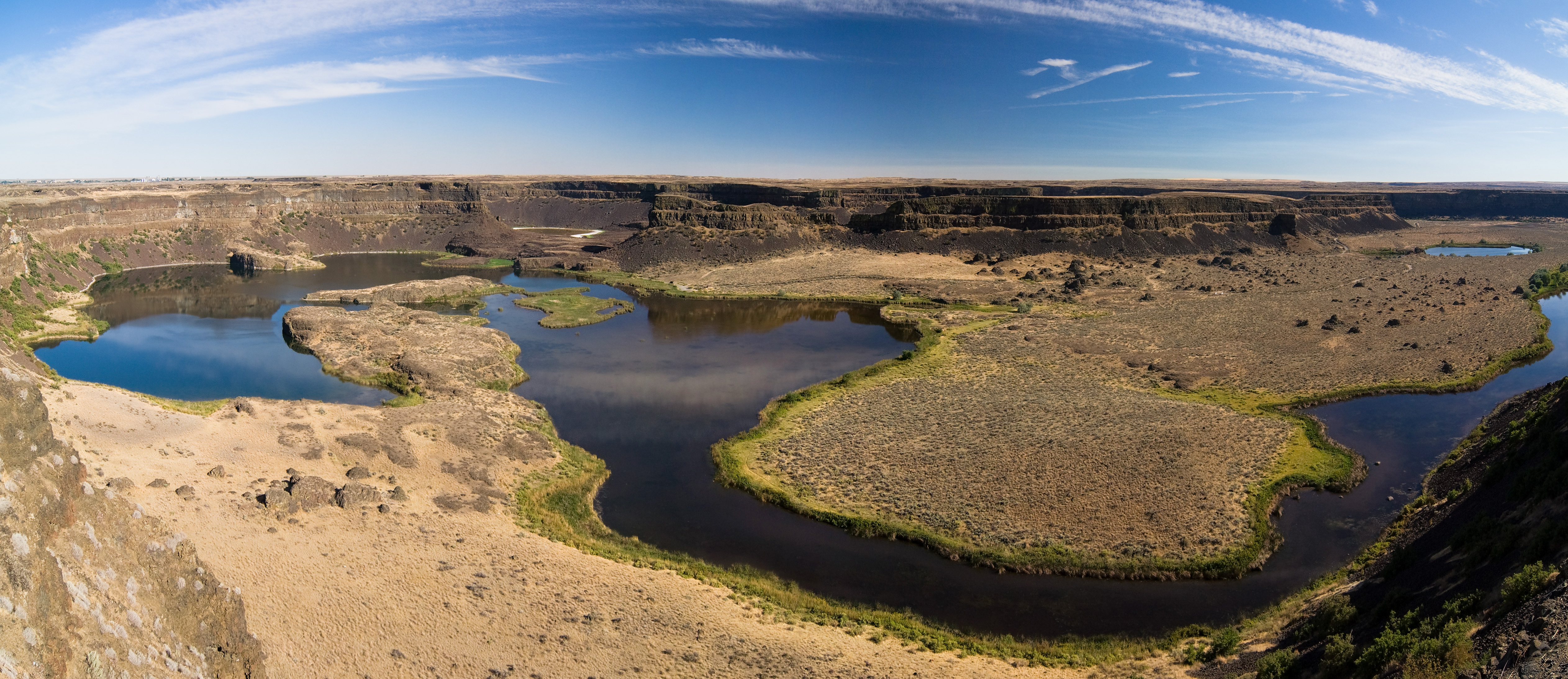
Dry Falls, WA Français : Les Dry Falls dans l'...

Dry Falls in Grand Colee, Washington state, US, showing typical features of the Channelle Scablands. (credit: Wikipedia)

In the 1920s J. Harlen Bretz suggested that the Channelled Scablands had been formed by a massive flood, a view that met disbelief until his colleague Joseph Pardee discovered that a huge lake of glacial meltwater (Lake Missouala) had formed in the intricate valleys of the Montana Rockies when their outflow into Washington had been blocked by a southward-surging finger of the Cordilleran ice sheet. Lake Missouala is estimated to have been about half the size of modern Lake Michigan (~7700 km2) and up to 610 m deep, reaching a maximum volume of 2100 km3  between 15 to 13 ka ago. Bretz’s idea was vindicated; melting of the ice dam was widely thought to have produced a single vast outburst flood and the removal of approximately 320 km3 of basalt and loess. The later discovery of strandlines, similar to those on a smaller scale in Glen Roy, western Scotland, on the flanks of former lake modified the theory to a series of individual, but still huge outburst flood events. Their magnitudes, estimated by assuming that each filled the coulees to their brim, were thought to be up to 60 km3 per hour, i.e. 100 times greater than the largest recorded historically, that of the Amazon. A recent study tempers the awe long-associated with the Scablands.

Isaac Larsen and Michael Lamb of the University of Massachusetts and the California Institute of Technology examined Moses Couleé, one of the largest, in detail (Larsen, I.J. & Lamb, M.P. 2016. Progressive incision of the Channelled Scablands by outburst floods. Nature, v. 538, p. 229-232; doi;10.1038/nature19817). Terraces in Moses Couleé allow successive topographic profiles of the canyon to be reconstructed, and the flow features on its floor allow water depth during some of the flows to be estimated. Far from being brim-full at any time, except during the first incision, individual discharges of meltwater were probably 5 to 10 times less than those previously suggested. Moreover, the pattern of the Scablands reflects major fracture zones n the Columbia River flood basalts, which suggests that floods followed lines of least resistance and greatest ease of erosion by removal of joint-bound blocks of basalt. Yet the floods still reached a magnitude never recorded for modern ones, and Larsen and Lambs modelling may well apply to the even vaster outburst canyons on Mars, such as Valles Marineris.

See also: Perron, J.T. & Venditti, J.G. 2016, Megafloods downsized. Nature, v. 538, p. 174-175; nature.com/newsandviews

Fresh offshore groundwater resources

There are paradoxes with groundwater: while over-use of coastal aquifers may draw in seawater to become undrinkable, on reef islands with no surface water adequate supplies may be had from fresh groundwater ‘floating’ on deeper, denser salt water. Seemingly even more odd, there are places several kilometres off some coastlines where freshwater rises in large volumes to the surface from springs on the sea floor.

Despite this and the fact that onshore aquifers extend far out to sea on continental shelves, hydrogeologists have paid scant attention to the potential water supplies that they might offer. Indeed, around the Persian Gulf where many submarine fresh springs are known petrodollars have poured into desalination rather than cheaper drilling and pipelines to the aquifers feeding the springs.

Reviewing the known potential of offshore groundwater, which occurs seawards of most continental shores, Vincent Post of Flinders University, Australia and colleagues from Holland, the US and Britain, consider that the global potential might be as high as half a million cubic kilometres (Post, V.E.A. et al. 2013. Offshore fresh groundwater reserves as a global phenomenon. Nature , v. 504, p. 71-78), around one tenth that of shallow (<750 m deep) groundwater onshore . It should be noted that the maximum safe level of salts dissolved in drinking water is about 1 gram per litre, and double that for irrigation water. The best prospects are where aquifers are trapped beneath impermeable sedimentary layers that prevent downward contamination by salt water.

The key to explaining such huge reserves is dating the water. In those places where that has been done the water is older than the Holocene (i.e. > 11 ka), which suggests infiltration when sea level was as much as 130 m lower than in interglacial periods, due to storage of evaporated seawater in major ice sheets. That would have exposed vast areas of what is now the sea floor to recharge. Modelling downward diffusion of seawater as sea level rose suggests that interglacials have too short to fully flush fresh water from the now submarine aquifers. Nevertheless, recharge is not continual, so that exploiting the resource is akin to ‘mining’ water. Yet the potential may prove essential in some coastal regions, and the authors caution against contamination by human activities offshore, such as exploration drilling for petroleum and carbon dioxide sequestration.

The review points out that submarine hydrogeology is one of the last great challenges in analysis of sedimentary basins.

Record of rising Holocene sea-level in the tropics

Areas beyond the zones of isostatic depression by ice-loading and recovery during glacial-interglacial cycles passively undergo sea-level fall and inundation. They best record the progress of Holocene ice-sheet melting and sea-level rise since 11.5 ka, especially if they are tectonically stable. The island state of Singapore, 1.5 º north of the Equator, is a near-ideal place for study (Bird, M.I.et al. 2010. Punctuated eustatic sea-level rise in the early mid-Holocene.Geology, v. 38, p. 803-806). The Australian and British geoscientists analysed a core through sediments in a mangrove swamp now just below sea level. The top 14 m penetrated a uniform though laminated sequence of marine muds, calibrated to time by radiocarbon dating of mollusc shells, mainly focused on the period from 9 to 6 ka period that the global oxygen-isotope record of ice volume suggests to have been the main period of final melting after the Younger Dryas.

Sedimentation was very rapid (~1 cm y-1) from  8.5 to 7.8 ka, probably as sea level rose too rapidly for the coast to be protected by mangrove growth.  Then for 400 years it slackened off to ~0.1 cm y-1 to rise again to 0.5 cm y-1 by 6.5 ka. The last date is the time of the mid-Holocene sea level highstand, after which sedimentation rate soon declined to 0.05 cm y-1, when mangroves became established at the site. Stable isotopes of carbon in the core (δ13C) show how the relative input of marine and terrestrial (mainly mangroves) organisms shifted over the period and are a proxy for the distance to the coastline and hence sea level. From 8.5 to 6.5 ka this was erratic from a starting point about 10 m lower than nowadays, showing rapid rises and falls that culminated in a sea level in Singapore about 3 m above present during the mid-Holocene sea level highstand that slowly declined to that of the present.

The team’s findings tally with evidence for the melting record of the North American ice sheet. An interesting aspect is that they also cover the period when rice cultivation in swampy areas of SE Asia got underway (~7.7 ka). Very rapid sedimentation would have encouraged development of the substrate for the highly fertile delta plains that now support the largest regional population densities on Earth. In turn they culminated in a series of early south and east Asian civilisations based on class societies.