Category Archives: Geochemistry, mineralogy, petrology and volcanology

Fossil fuel, mercury and the end-Palaeozoic catastrophe

Read about this at Earth-logs

Maintenance of Earth-pages has stopped. If you wish to continue following reports on significant research developments in Earth science you can register as a follower of my new blog at the Earth-logs site

Changing conditions of metamorphism since the Archaean

Read about this at Earth-logs

Maintenance of Earth-pages has stopped. If you wish to continue following reports on significant research developments in Earth science you can register as a follower of my new blog at the Earth-logs site

Earliest plate tectonics tied down?

Read about this at Earth-logs

Maintenance of Earth-pages has stopped. If you wish to continue following reports on significant research developments in Earth science  you can register as a follower of my new blog at the Earth-logs site

Closure for the K-Pg extinction event?

Read about this at Earth-logs

Maintenance of Earth-pages has stopped. If you wish to continue following my brief reports on significant research developments in Earth science  you can register as a follower of the new blog at the Earth-logs site

Earth’s water and the Moon

Note: Earth-Pages will be closing as of early July, but will continue in another form at Earth-logs

Where did all our water come from? The Earth’s large complement of H2O, at the surface, in its crust and even in the mantle, is what sets it apart in many ways from the rest of the rocky Inner Planets. They are largely dry, tectonically torpid and devoid of signs of life. For a long while the standard answer has been that it was delivered by wave after wave of comet impacts during the Hadean, based on the fact that most volatiles were driven to the outermost Solar System, eventually to accrete as the giant planets and the icy worlds and comets of the Kuiper Belt and Oort Cloud, once the Sun sparked its fusion reactions That left its immediate surroundings depleted in them and enriched in more refractory elements and compounds from which the Inner Planets accreted. But that begs another question: how come an early comet ‘storm’ failed to ‘irrigate’ Mercury, Venus and Mars? New geochemical data offer a different scenario, albeit with a link to the early comet-storms paradigm.

earth-moon

Simulated view of the Earth from lunar orbit: the ‘wet’ and the ‘dry’. (credit: Adobe Stock)

Three geochemists from the Institut für Planetologie, University of Münster, Germany, led by Gerrit Budde have been studying the isotopes of the element molybdenum (Mo) in terrestrial rocks and meteorite collections. Molybdenum is a strongly siderophile (‘iron loving’) metal that, along with other transition-group metals, easily dissolves in molten iron. Consequently, when the Earth’s core began to form very early in Earth’s history, available molybdenum was mostly incorporated into it. Yet Mo is not that uncommon in younger rocks that formed by partial melting of the mantle, which implies that there is still plenty of it mantle peridotites. That surprising abundance may be explained by its addition along with other interplanetary material after the core had formed. Using Mo isotopes to investigate pre- and post-core formation events is similar to the use of isotopes of other transition metals, such as tungsten (seePlanetary science, May 2016).

Budde and colleagues showed that the 95Mo and 94Mo abundances in water- and carbon-poor meteorites that come from the Asteroid Belt and formed in the inner Solar System differ consistently from those in volatile-rich carbonaceous chondrites that formed much further away from the Sun. The average abundances of the two molybdenum isotopes in the Earth’s silicate rocks, which ultimately had their origin in the mantle, fall between those of the two classes of meteorites (Budde, G. et al.  2019. Molybdenum isotopic evidence for the late accretion of outer Solar System material to Earth. Nature Astronomy, v. 3, online ; DOI: 10.1038/s41550-019-0779-y). They must reflect the materials that accreted after core formation. If the 95Mo and 94Mo abundances resembled those in non-carbonaceous, dry meteorites that would suggest late accretion with much the same composition as expected from Earth’s position in the Inner Solar System. Alternatively, some molybdenum from Earth’s original formative materials failed to unite with iron in the core. The Mo ‘signature’ of volatile-rich carbonaceous meteorites in the mantle’s make-up points to a large amount of accreting material from the Outer Solar System. In contrast, lunar rocks show no carbonaceous meteorite component of Mo isotopes, which helps to explain its overall dryness compared with the Earth. Yet, the Moon is strongly believed to have formed from material blasted away by an impact between the proto-Earth and an errant, Mars-sized body (Theia).

The authors suggest a high probability that Theia was a carbon- and volatile-rich body from the outer Solar System flung inwards by gravitational perturbation associated with the then unstable orbits of the giant planets Jupiter and Saturn. In that case Theia could have delivered not only the anomalous molybdenum, but most of Earth’s water and other volatile compounds.   If the theory is correct, then the cataclysmic event that formed the Moon laid the basis for Earth’s continual tectonic activity and its eventually sparking up life; without the Moon, there would be no life on Earth. That kind of chance event isn’t a factor considered in either the Drake Equation or the Goldilocks Zone. Life, natural selection and sentient beings that might spring from them may be a great deal more elusive than commonly believed by exobiologists.

See also: Formation of the moon brought water to Earth (Science Daily, 21 May 2019)

Better dating of Deccan Traps, and the K-Pg event

Predictably, the dialogue between the supporters of the Deccan Trap flood basalts and the Chicxulub impact as triggers that were responsible for the mass extinction at the end of the Mesozoic Era (the K-Pg event) continues. A recent issue of Science contains two new approaches focussing on the timing of flood basalt eruptions in western India relative to the age of the Chicxulub impact.

407458aa.2

The Deccan Traps in the Western Ghats of India (Credit: Wikipedia)

This item can be read in full at Earth-logs, which replaces Earth-pages


Volcanism and the Justinian Plague

Between 541 and 543 CE, during the reign of the Roman Emperor Justinian, bubonic plague spread through countries bordering the Mediterranean Sea. This was a decade after Justinian’s forces had had begun to restore the Roman Empire’s lost territory in North Africa, Spain, Italy and the present-day Balkans by expeditions out of Byzantium (the Eastern Empire). At its height, the Plague of Justinian, was killing 5000 people each day in Constantinople, eventually to consume 20 to 40% of its population and between 25 to 50 million people across the empire. Like the European Black Death of the middle 14th century. The bacterium Yersinia pestis originated in Central Asia and is carried in the gut of fleas that live on rats. The ‘traditional’ explanation of both plagues was that plague spread westwards along the Silk Road and then with black rats that infested ship-borne grain cargoes. Plausible as that might seem, Yersinia pestis, fleas and rats have always existed and remain present to this day. Trade along the same routes continued unbroken for more than two millennia. Although plagues with the same agents recurred regularly, only the Plague of Justinian and the Black Death resulted in tens of million deaths over short periods. Some other factor seems likely to have boosted fatalities to such levels.

407458aa.2

Monk administering the last rites to victims of the Plague of Justinian

Five years before plague struck the Byzantine historian Procopius recorded a long period of fog and haze that continually reduced sunlight; typical features of volcanic aerosol veils. Following this was the coldest decade in the past 2300 years, as recorded by tree-ring studies. It coincides with documentary evidence of famine in China, Ireland, the Middle East and Scandinavia.. A 72 m long ice core extracted from the Colle Gnifetti glacier in the Swiss Alps in 2013 records the last two millennia of local climatic change and global atmospheric dust levels. Sampled by laser slicing, the core has yielded a time series of data at a resolution of months or better. In 536 an Icelandic volcano emitted ash and probably sulfur dioxide over 18 months during which summer temperature fell by about 2°C. A second eruption followed in 540 to 541. ‘Volcanic winter’ conditions lasted from 536 to 545, amplifying the evidence from tree-ring data from the 1990’s.

The Plague of Justinian coincided with the second ‘volcanic winter’ after several years of regional famine. This scenario is paralleled by the better documented Great Famine of 1315-17 that ended the two centuries of economic prosperity during the 11th to 13th centuries. The period was marked by extreme levels of crime, disease, mass death, and even cannibalism and infanticide. In a population weakened through malnutrition to an extent that we can barely imagine in modern Europe, any pandemic disease would have resulted in the most affected dying in millions. Another parallel with the Plague of Justinian is that it followed the ending of four centuries of the Medieval Warm Period, during which vast quantities of land were successfully brought under the plough and the European population had tripled. That ended with a succession of major, sulfur-rich volcanic eruption in Indonesia at the end of the 13th century that heralded the Little Ice Age. Although geologists generally concern themselves with the social and economic consequences of a volcano’s lava and ash in its immediate vicinity– the ‘Pompeii view’ – its potential for global catastrophe is far greater in the case of really large (and often remote) events.

Chemical data from the same ice core reveals the broad economic consequences of the mid-sixth century plague. Lead concentrations in the ice, deposited as airborne pollution from smelting of lead sulfide ore to obtain silver bullion, fell and remained at low levels for a century. The recovery of silver production for coinage is marked by a spike in glacial lead concentration in 640; another parallel with the Black Death, which was followed by a collapse in silver production, albeit only for 4 to 5 years.

Related article: Gibbons, A. 2018. Why 536 was ‘the worst year to be alive’. Science, v. 362,p. 733-734; DOI:10.1126/science.aaw0632

Read more on Geohazards, Magmatism and Palaeoclimatology

Oceanic hydrothermal vents and the origin of life

A range of indirect evidence has been used to suggest that life originated deep in the oceans around hydrothermal vents, such as signs of early organic matter in association with Archaean pillow lavas. One particularly persuasive observation is that a number of proteins and other cell chemicals are constructed around metal sulfide groups. Such sulfides are common around hydrothermal ‘smokers’ associated with oceanic rift systems. Moreover, Fischer-Tropsch reactions between carbon monoxide and hydrogen produce quite complex hydrocarbon molecules under laboratory conditions. Such hydrogenation of a carbon-bearing gas requires a catalyst, a commonly used one being chromium oxide (see Abiotic formation of hydrocarbons by oceanic hydrothermal circulation May 2004). It also turns out that fluids emitted by sea-floor hydrothermal systems are sometimes rich in free hydrogen, formed by the breakdown of olivine in ultramafic rocks to form hydroxylated minerals such as serpentine and talc. The fact that chromium is abundant in ultramafic rocks, in the form of its oxide chromite, elevates the possibility that Fischer-Tropsch reactions may have been a crucial part of the life-forming process on the early Earth. What is needed is evidence that such reactions do occur in natural settings.

407458aa.2

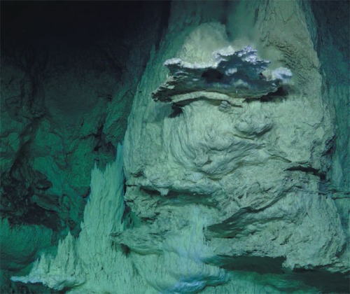
A white carbonate mound forming at the Lost City hydrothermal vent field on the Mid-Atlantic Ridge (Credit: Baross 2018)

One site on the mid-Atlantic ridge spreading centre, the Lost City vent field, operates because of serpentinisation of peridotites exposed on the ocean floor, to form carbonate-rich plumes and rocky towers; ‘white smokers’. So that is an obvious place to test the abiotic theory for the origin of life. Past analyses of the vents have yielded a whole range of organic molecules, including alkanes, formates, acetates and pyruvates, that are possible precursors for such a natural process. Revisiting Lost City with advanced analytical techniques has taken the quest a major step forward (Ménez, B. et al. 2018. Abiotic synthesis of amino acids in the recesses of the oceanic lithosphere. Nature, advance online publication; DOI: 10.1038/s41586-018-0684-z). The researchers from France and Kazakhstan focused on rock drilled from 170 m below the vent system, probably beyond the influence of surface contamination from living organisms. Using several methods they detected the nitrogen-containing amino acid tryptophan, and that alone. Had they detected other amino acids their exciting result would have been severely tempered by the possibility of surface organic contamination. The formation of tryptophan implies that its abiotic formation had to involve the reduction of elemental nitrogen (N2) to ammonia (NH3). Bénédicte Ménez and colleagues suggest that the iron-rich clay saponite, which is a common product of serpentine alteration at low temperatures, may have catalysed such reduction and amino-acid synthesis through Friedel–Crafts reactions. Fascinating as this discovery may be, it is just a step towards confirming life’s abiogenesis. It also permits speculation that similar evidence may be found elsewhere in the Solar System on rocky bodies, such as the moons Enceladus and Europa that orbit Saturn and Jupiter respectively. That is, if the rock base of hydrothermal systems thought to occur there can be reached.

Related article: Baross, J.A. 2018. The rocky road to biomolecules. Nature, v. 564, p. 42-43; DOI: 10.1038/d41586-018-07262-8.

Hot-spot track beneath the Greenland ice cap

Around 63 Ma ago, during the Palaeocene Epoch, major igneous activity broke out in what are now both sides of the North Atlantic Ocean. After initial sputtering it culminated massively between 57 and 53 Ma. Relics are to be seen in Baffin Island, West and East Greenland, the Faeroes and north-western parts of the British Islands, in the form of flood basalts, dyke swarms and scattered remnants of central volcanoes. Offshore drilling on the North Atlantic’s continental shelves suggests that the volcanism extended over 1.3 million km2 and blurted out around 6.6 million km3 of magma. Not for nothing have the products of this event been categorised as a Large Igneous Province. Its formation took place before the North Atlantic existed. It began to form as this precursor magmatic paroxysm waned.  Continued basaltic magma production created the ocean floor each side of the mid-Atlantic Ridge system to divide North America and Greenland from northern Europe. Sea floor spreading continues, rising above sea level in Iceland, which is underlain by a large mantle plume.

The plume beneath Iceland may have been present at a fixed position in the mantle for tens of million years. A hot spot over which plate movements have shifted lithosphere to be heated in a similar way to a sheet of paper dragged slowly over a candle flame. The Iceland plume may have left a hot-spot track similar to that involved in the Hawaiian island chain. The ocean floor to the east and west of Iceland is shallower and forms broad rides at right angles to the trend of the Mid-Atlantic Ridge system, judged to be such tracks that are still warm and buoyant after formation over the plume. But are there traces of earlier passage of drifting lithosphere over the plume. A way to detect older hot-spot tracks is through variations in geothermal heat flow through the continental surface, a linear pattern raising suspicions of such trace of passage. There is no sign to the east beneath Europe, so what about to the west. Greenland, being mainly blanketed in ice, is not a good place to conduct such a search as it would involve deep drilling through the ice at huge cost for each hole. But there is a roundabout way of obtaining geothermal information without even setting foot on Greenland’s icy wastes.

The geomagnetic field measured at the surface records anomalies in rock magnetisation in the solid Earth beneath. Near-surface variations due to large variations in rock types that comprise the continental crust appear as sharp, high frequency signals. Aeromagnetic surveys over Greenland are characterised by such noisy patterns because the subsurface geology is extremely complicated. However, the underlying upper mantle beneath all continents is geologically quite bland, but being uniformly rich in iron it contains a high proportion of magnetic minerals such as magnetite (Fe3O4). The upper mantle should therefore leave a signal in the surface geomagnetic field, albeit a commensurately bland one. Like radio signals that span a large range of wavelengths, Earth properties that vary spatially, such as the geomagnetic field, may be analysed using filters. Once the high-frequency geomagnetic features of the crust are filtered out what should remain is a signal that reflects the magnetic structure of the upper mantle. It should be more or less featureless, yet beneath Greenland it isn’t.

greenland hot spot

Estimated Curie depth variation below Greenland (left) converted to geothermal heat flow variation (right). (Credit: Martos et al. 2018; Figures 1b and 1c)

Magnetic anomalies are created by magnetisation induced in magnetic minerals in rocks by the Earth’s magnetic field. Yet minerals lose their ability to be magnetised at temperatures above a threshold known as the Curie point, which is 580 °C for magnetite, the most abundant magnetic mineral. Depending on the geothermal heat flow the Curie point is exceeded at some depth in the lithosphere. So magnetic anomalies can safely be assumed to be produced only by rocks above the so-called Curie depth. Yasmina Martos of the British Antarctic Survey (now at the University of Maryland) and scientists from Britain, the US and Spain used a complex procedure, including gravity data and a few direct measurements of heat flow below Greenland as well as filtered aeromagnetic data, to estimate the variation in Curie depth beneath the ice cap. (Martos, Y.M. et al. 2018. Geothermal heat flux reveals the Iceland hotspot track underneath Greenland. Geophysical Research Letters, v. 45, online publication; doi: 10.1029/2018GL078289). Using that as an inverse proxy for heat flow they were able to map the likely geothermal variation beneath the island. Rather than a random and narrow variation in depth, as would be expected for roughly uniform heat flow, the Curie depth varied in a non-random way by over 20 km, equivalent to roughly 20 mW m-2.

The shallowest Curie depth and highest estimated heat flow occurs in East Greenland around Scoresby Sund where the largest sequence of Palaeocene flood basalts occur. It is also on a line perpendicular to the mid-Atlantic Rift system that meets the active Iceland plume. Running north-west from Scoresby Sund is a zone of locally high estimated heat flow. Martos et al. suggest that this is the track of Greenland’s motion over the Iceland hot spot from about 80 Ma to the period of maximum on-shore volcanism and the start of sea-floor spreading at around 50 Ma.

A fully revised edition of Steve Drury’s book Stepping Stones: The Making of Our Home World can now be downloaded as a free eBook

Volcano heading for the sea

John Murray of The Open University, UK has been studying Europe’s largest active volcano Mount Etna on Sicily for most of his career. With a group of colleagues he installed high-precision GPS receivers at over 100 stations on the flanks of the mountain. This was to monitor any shifts in elevation and geographic position, which might be related to magmatic events within the volcano, such as inflation and contraction of the magma chamber. Measurements of position gathered annually since 2001 reveal a somewhat alarming picture (Murray, J.B. et al. 2018. Gravitational sliding of the Mt. Etna massif along a sloping basement. Bulletin of Volcanology, v. 80 online, open access; doi /10.1007/s00445-018-1209-1). The edifice is moving relentlessly ESE at 14 mm yr-1, on average, towards the Mediterranean Sea. Research by one of Murray’s co-authors, Benjamin van Wyk de Vries of the Université Clermont Auvergne, established that many volcanoes have associated signs of deformation due to their huge masses. Often, this is a matter of radial spreading that produces thrust-like faults at their base and in the basement on which they grew. In the case of Etna all the annual displacements on its flanks are skewed to the ESE. The researchers are able to show that this is not a case of flank instability that ultimately may result in lateral collapse but the entire volcano is slowly slipping sideways.

English: Mount Etna, Sicily, topped in snow It...

Mount Etna, Sicily, topped in snow (credit: Wikipedia)

An experimental mock up of the volcano– a cone and flanking layers of lava and pyroclastic rocks made of sand on a substrate of putty to represent underlying sedimentary strata – began to slide once it was tilted at a shallow angle. This suggests that the base of the volcano and igneous debris that it has emitted dips gently to the ESE. The underlying materials are poorly consolidated Quaternary sediments, which are likely to be rheologically weak. Geophysics shows that the NW side of the volcano rests on an almost horizontal plateau, the cone itself being above a spoon-like depression, probably produced by the cone’s mass, and the base dips seawards  in the SE sector. It is through this basement that magma makes its way to Etna’s summit vent system, probably along fractures.

The authors warn that such sliding volcanoes are prone to devastating sector collapse on the downslope side, although there are no signs that might be imminent. Yet it will almost certainly have an effect on eruptive activity as the magma conduits are continually changing. Future research needs to focus on periods when there is horizontal contraction on the volcano, as happens during lengthy periods of dormancy – the period for which there are data has been one of expansion.